INSPIRE Metadatensuche Österreich
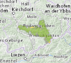
Nationalpark Zonierung Oberösterreich
Zonierung des Nationalpark Kalkalpen in Natur- und Bewahrungszone entsprechend dem Oö. Nationalparkgesetz in der jeweils gültigen Fassung der Nationalparkerklärung "Oö. Kalkalpen".
Dieser Datensatz wird über INSPIRE zur Verfügung gestellt.
Simple
- Alternativtitel
-
DORIS_U.GISDB.NATIONALPARK_ZONIERUNG
- Datumsangaben (Erstellung)
- 2023-01-19
- Datumsangaben (Publikation)
- 2023-01-19
- Identifikator
- https://data.inspire.gv.at/0021/26964716-98FA-4201-955A-E4CA2182128F
- Kontakt für die Ressource
-
Organisation Person E-Mail Funktion Amt der OÖ. Landesregierung
Mag., Günter, Dorninger
Ansprechpartner
- Überarbeitungsintervall
- Unbekannt
-
GEMET - Concepts, version 2.4
-
-
Schutzgebiet
-
-
OGD Kategorien
-
-
Umwelt
-
Geographie und Planung
-
-
OGD Keyword
-
-
Schutzgebiete
-
Biologie
-
Natur
-
Naturschutz
-
NP
-
Nationalparks
-
HighValueDataset
- HVD
-
- Keywords
-
-
Schutzgebiete
-
Biologie
-
Natur
-
Naturschutz
-
NP
-
Nationalparks
-
HighValueDataset
-
Internetfreigabe
-
OGDFreigabe
- HVD
-
- Nutzungseinschränkungen
- Benutzerdefinierte Einschränkungen
- Andere Einschränkungen
- Creative Commons Namensnennung 4.0 International (CC BY 4.0)
- Andere Einschränkungen
-
Datenquelle: Land Oö., doris.at
- Zugriffseinschränkungen
- Benutzerdefinierte Einschränkungen
- Andere Einschränkungen
- Der öffentliche Zugang zu diesem Produkt unterliegt keinen Einschränkungen.
- Sicherheitseinstufung
- Unbeschränkt
- Räumliche Darstellungsart
- Vektor
- Maßstabszahl
- 1
- Sprache
- Deutsch
- Zeichensatz
- Utf8
- ISO-Thematik
-
- Grenzen
- Biologie
- Planungsunterlagen, Kataster
- Umwelt
))
- Code
- EPSG:31255
- Code
- EPSG:3045
- Geometrietyp
- Körper
- Abgabeformat
-
Bezeichnung Version gml+xml 3.2
- Kontakt
-
Organisation Person E-Mail Funktion Land Oberösterreich - Amt der OÖ- Landesregierung Ansprechpartner
Digitale Transferoptionen
- Online
-
Protokoll URL Bezeichnung OGC Web Map Service
https://ags.doris.at/arcgis/services/INSPIRE/MapServer/WMSServer?request=GetCapabilities&service=WMS&version=1.3.0 INSPIRE Darstellungsdienst
ATOM Syndication Format
https://doris.ooe.gv.at/service/metadaten/DownloadDienstMetadataAtom.xml INSPIRE Downloaddienst
WWW:DOWNLOAD-1.0-http--download
https://e-gov.ooe.gv.at/at.gv.ooe.dorisdaten/DORIS_U/NATIONALPARK_ZONIERUNG.zip Nationalpark Zonierung Oberösterreich
WWW:DOWNLOAD-1.0-http--download
https://www.doris.at/service/metadaten/daten/Nationalpark_Zonierung_ETRS89TM33N.zip Nationalpark Zonierung Oberösterreich
OGC:WFS-http-get-capabilities
https://ags.doris.at/arcgis/services/HVD/MapServer/WFSServer?request=GetCapabilities&service=WFS Web Feature Service (WFS)
- Bezugsebene
- Datenbestand
Konformitätsergebnis
- Titel
-
Verordnung (EG) Nr. 1089/2010 der Kommission vom 23. November 2010 zur Durchführung der Richtlinie 2007/2/EG des Europäischen Parlaments und des Rates hinsichtlich der Interoperabilität von Geodatensätzen und -diensten
- Datumsangaben (Publikation)
- 2010-12-08
- Erklärung
-
Dieser Datensatz entspricht den INSPIRE-Implementierungsregeln für die Interoperabilität von Geodatensätzen und -diensten
- Bestanden
- Ja
- Erläuterung
-
Nationalparks wurden auf Basis der DKM digitalisiert, aber stellt jedoch keine rechtlich verbindliche Abgrenzungen dar. Vielmehr ist das Hauptanliegen bei der Erstellung des GENISYS die Verfügbarkeit der Daten im Übersichtsformat, so dass die planenden Stellen jederzeit eine aktualisierte Übersicht über die in Oberösterreich vorhandenen naturschutzrechtlich relevanten Flächen greifbar haben.
Metadaten
- Metadatensatzidentifikator
- 26964716-98FA-4201-955A-E4CA2182128F XML
- Sprache
- Deutsch
- Zeichensatz
- Utf8
- Hierarchieebene
- Datenbestand
- Datum
- 2026-04-13T09:34:07.155Z
- Bezeichnung des Metadatenstandards
-
ISO 19115:2003/19139
- Version des Metadatenstandards
-
1.0
- Metadatenkontakt
-
Organisation Person E-Mail Funktion Amt der OÖ. Landesregierung
Mag., Günter, Dorninger
Ansprechpartner
- URI des Datenbestands
-
H:\arcgis\Layerfiles\Umwelt\Grenzen\Nationalpark_Zonierung.lyrx
Overviews
Räumliche Ausdehnung
Provided by