INSPIRE Metadatensuche Österreich
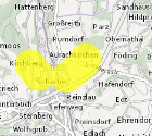
Wildtierkorridore (Gelb-Zonen) Oberösterreich
Ausweisung jener Abschnitte im überregional wirksamen Biotopverbund (zur Sicherstellung der Vernetzung von Lebensräumen von waldgebundenen Wildtieren mit großflächigen Habitatansprüchen), welche eine reduzierte Funktionalität aufgrund eingeschränkter Durchlässigkeit der Landschaft aufweisen.
Dieser Datensatz wird über INSPIRE zur Verfügung gestellt.
Simple
- Alternate title
-
DORIS_U.GISDB.WILDTIERKORRIDORE_GELBZONEN
- Date (Publication)
- 2011-12-30
- Date (Creation)
- 2011-12-30
- Date (Revision)
- 2026-07-07
- Citation identifier
- https://data.inspire.gv.at/0021/F0929A0E-406A-4578-9518-E7172953AA8C
- Point of contact
-
Organisation name Individual name Electronic mail address Role Amt der OÖ. Landesregierung
Mag, Dr, Mario, Pöstinger
Point of contact
- Maintenance and update frequency
- Unknown
-
GEMET - Concepts, version 2.4
-
-
Wildtier
-
-
OGD Kategorien
-
-
Umwelt
-
-
OGD Keyword
-
-
Lebensräume
-
Biotope
-
Wildtiere
-
HighValueDataset
- HVD
-
- Keywords
-
-
Lebensräume
-
Biotope
-
Wildtiere
-
HighValueDataset
-
Internetfreigabe
-
OGDFreigabe
- HVD
-
- Use constraints
- Other restrictions
- Other constraints
- Creative Commons Namensnennung 4.0 International (CC BY 4.0)
- Other constraints
-
Datenquelle: Land Oö., doris.at
- Access constraints
- Other restrictions
- Classification
- Unclassified
- Spatial representation type
- Vector
- Denominator
- 10000
- Language
- Deutsch
- Character set
- UTF8
- Topic category
-
- Biota
- Planning cadastre
- Transportation
))
- Unique resource identifier
- EPSG:31255
- Unique resource identifier
- EPSG:3045
- Geometric object type
- Surface
- Distribution format
-
Name Version gml+xml 3.2
- Distributor contact
-
Organisation name Individual name Electronic mail address Role Land Oberösterreich - Amt der OÖ- Landesregierung Point of contact
Digital transfer options
- OnLine resource
-
Protocol Linkage Name OGC Web Map Service
https://ags.doris.at/arcgis/services/INSPIRE/MapServer/WMSServer?request=GetCapabilities&service=WMS&version=1.3.0 INSPIRE Darstellungsdienst
ATOM Syndication Format
https://doris.ooe.gv.at/service/metadaten/DownloadDienstMetadataAtom.xml INSPIRE Downloaddienst
WWW:DOWNLOAD-1.0-http--download
https://e-gov.ooe.gv.at/at.gv.ooe.dorisdaten/DORIS_U/WILDTIERKORRIDORE_GELBZONEN.zip Wildtierkorridore (Gelb-Zonen) Oberösterreich
WWW:DOWNLOAD-1.0-http--download
https://www.doris.at/service/metadaten/daten/WILDTIERKORRIDORE_GELBZONEN_ETRS89TM33N.zip Wildtierkorridore (Gelb-Zonen) Oberösterreich
OGC:WFS-http-get-capabilities
https://ags.doris.at/arcgis/services/HVD/MapServer/WFSServer?request=GetCapabilities&service=WFS Web Feature Service (WFS)
- Hierarchy level
- Dataset
Conformance result
- Title
-
Verordnung (EG) Nr. 1089/2010 der Kommission vom 23. November 2010 zur Durchführung der Richtlinie 2007/2/EG des Europäischen Parlaments und des Rates hinsichtlich der Interoperabilität von Geodatensätzen und -diensten
- Date (Publication)
- 2010-12-08
- Explanation
-
Dieser Datensatz entspricht den INSPIRE-Implementierungsregeln für die Interoperabilität von Geodatensätzen und -diensten
- Pass
- Yes
- Statement
-
Ergebnis aus der Studie "Wildtierkorridore in Oberösterreich", erstellt in Zusammenarbeit von den Abteilungen Naturschutz, Raumordnung sowie Land- und Forstwirtschaft beim Amt der Oö. Landesregierung, dem Oö. Landesjagdverband und der Oö. Umweltanwaltschaft. Datengrundlage war das Positionspapier "Wildtierkorridore" der Oö. Umweltanwaltschaft aus dem Jahr 2009. Diese Daten wurden unter Anwendung GIS-gestützter Modellrechnungen (Habitatanalyse, Raumwiderstandsanalyse) auf Basis der DKM und der aktuellen Orthofotos evaluiert und überarbeitet.
Metadata
- File identifier
- F0929A0E-406A-4578-9518-E7172953AA8C XML
- Metadata language
- Deutsch
- Character set
- UTF8
- Hierarchy level
- Dataset
- Date stamp
- 2026-07-07T07:42:23.283Z
- Metadata standard name
-
ISO 19115:2003/19139
- Metadata standard version
-
1.0
- Metadata author
-
Organisation name Individual name Electronic mail address Role Amt der OÖ. Landesregierung
Mag, Dr, Mario, Pöstinger
Point of contact
- Dataset URI
-
H:\arcgis\Layerfiles\Umwelt\Biologie\Gelbzonen.lyrx
Overviews
Spatial extent
Provided by